Disaster Prevention Information (防災情報)
更新日:2026年2月25日
ページ番号:19584839
①Nishinomiya Disaster Information Portal(西宮市防災ポータル)
リンク
・Disaster prevention and weather information(外部サイト)![]()
・Evacuation information(外部サイト)![]()
・Life support services information(外部サイト)![]()
➁Evacuation Shelters(避難所一覧)
リンク
- Evacuation Shelters(外部サイト)

- In case of an earthquake(PDF:224KB)
- In times of typhoons and floods(PDF:196KB)
③Map of Emergency Water Supply Stations at the Time of a Disaster(災害時応急給水ステーションマップ)
ダウンロード
- Surrounding Area of City Hall Main Office(PDF:543KB)
- Kawaragi Area(PDF:249KB)
- Koto Area(PDF:319KB)
- Naruo Area(PDF:290KB)
- Northern Area(PDF:442KB)
④“Hyogo Emergency Net” (ひょうご防災ネット)
“Hyogo Emergency Net”is now available in 12 languages. (English, French, German, Chinese〈Simplified〉, Chinese 〈Traditional〉, Indonesian, Italian, Korean, Portuguese, Spanish, Thai, and Vietnamese)
To see how to subscribe, click the link below.
When you send an email from your cell phone to “Hyogo Emergency Net”, you will receive a return email. If you access the link in the return email and choose Nishinomiya as the desired area, you will receive emails with emergency information (e.g. evacuation calls) and various weather information, such as heavy rain warning, when distributed.
リンク
- Leaflet to recommend registration for “Hyogo Emergency Net”in 12 languages.(外部サイト)
- The registration method in Japanese is also available at this link.
- ※Other information :Information transmitting application,“Safety tips” for foreign travelers.(外部サイト)
⑤Disaster Prevention Portal (Ministry of Land, Infrastructure, Transportation and Tourism)(国土交通省:防災ポータル)
リンク
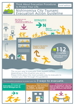
⑥"Nishinomiya City Tsunami Evacuation Action Guideline" brief edition(「西宮市津波避難行動指針」概要版)
This guide covers the evacuation action timeline from the occurrence of Nankai Trough Earthquake until the tsunami subsides which generally lasts for a dozen to 24 hours. Through this guide and drills, please think about the place of your residence and workplace, the situation you are in and what is the most suitable way to evacuate. Please make the tsunami evacuation plan that fits you the most.
ダウンロード
- Nishinomiya City Tsunami Evacuation Action Guideline: brief edition_number(PDF:19,248KB)
- Nishinomiya City Tsunami Evacuation Action Guideline: brief edition_multi language_comparison table(PDF:577KB)
PDF形式のファイルを開くには、Adobe Acrobat Readerが必要です。
お持ちでない方は、Adobe社から無償でダウンロードできます。
![]()